Glensaugh: Land Capabiilty for Agriculture
URL: https://druid.hutton.ac.uk/arcgis/services/Glensaugh/Glensaugh_LCA50K/MapServer/WMSServer
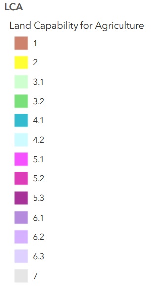
The Land Capability Classification for Agriculture has as its objective the presentation of detailed information on soil, climate and relief in a form which will be of value to land use planners, agricultural advisers, farmers and others involved in optimising the use of land resources. The classification ranks land on the basis of its potential productivity and cropping flexibility determined by the extent to which its physical characteristics (soil, climate and relief) impose long term restrictions on its agricultural use.
For the spatial data of the map click link below for download:
https://www.hutton.ac.uk/sites/default/files/files/glensaugh/Downloads/Glensaugh_LCA50K.zip
追加情報
| フィールド | 値 |
|---|---|
| 最終更新日 | 2020年5月19日 |
| メタデータ最終更新日時 | 2020年5月19日 |
| 作成日 | 2020年5月19日 |
| データ形式 | WMS |
| ライセンス | Other (Open) |
| Has views | True |
| Id | b8ff3101-d17c-4dfd-9462-f6a5c2121b5a |
| Package id | 30805668-9c53-402f-8049-f1672832450b |
| Position | 5 |
| State | active |